This report provides the first major output of a collaborative project to develop methods for the comprehensive economic analysis of the impacts of flood events, and to investigate the social impacts on communities of flooding, and their perceptions surrounding floods.
It also feeds into ongoing research on flood warning systems, preparedness, flooding impact mitigation and emergency response planning. The project and ongoing research are a collaboration between the Institute of Geological and Nuclear Sciences (GNS), the New Zealand Institute of Economic Research (NZIER), the Ministry for the Environment (MfE), the Ministry of Civil Defence and Emergency Management (MCDEM), the National Institute of Water and Atmospheric Research (NIWA), Meteorological Service of New Zealand Ltd (MetService), and regional and local government (Environment Waikato, Thames-Coromandel District Council and South Waikato District Council for the Weather Bomb event and this report).
The 'weather bomb 2002' was a low-pressure system that led to extensive flooding on the Coromandel Peninsula and the south-west Waikato region, including one loss of life. The New Zealand Climate Change Office, Environment Waikato and Ministry for Civil Defence and Emergency Management commissioned this study to estimate the economic impact of the weather bomb event on the region, and to better understand the way in which communities understand, perceive and prepare for such risks. The aim of this report is to assist local government decision-making, and to inform the development of the Climate Change Office work programme on the economic impacts of severe weather events.
The primary aims of this report and their relative emphasis within the report are:
- to evaluate the direct and indirect costs of the 'weather bomb' event. (40 %),
- to give a macroeconomic view of the event in terms of its region-wide economic effects. (40 %), and
- to provide an understanding of the impact on the community affected in terms of their preparedness and perception of risk (20 %).
These have been achieved through completion of the following objectives:
- A survey of a representative sample of those affected and unaffected by the weather bomb within the Coromandel Thames and South Waikato Districts, both private households and businesses.
- Compilation and analysis of insurance losses, both corporate and Earthquake Commission, via data from the insurers and data on insured and uninsured losses directly from the victims.
- Numerical macroeconomic modelling utilising regional and national economic data, survey and research results to provide a detailed understanding of the real economic dynamics and impacts surrounding the event.
- Interpretation of the community impact, vulnerability and resilience from a hazard/disaster psychology perspective.
The project includes a non-technical summary, separate to this report, that will be made available to those participating in the study (including flood victims), Regional and District Councillors, Regional and District Council staff and any interested members of the general public.
See Section 7.5 for details of the research that will build on the findings of this initial report.
The "weather bomb"-a potentially damaging low-pressure system-developed from a mid-latitude depression that formed off the coast of Queensland, Australia. This system rapidly deepened (Fig. 2) as it approached the northern tip of New Zealand, with the central pressure dropping at a rate of 16 hPa in 24 hours. It thus exceeded the internationally-accepted criteria, for our latitude, for a "weather bomb". Severe Weather Warnings issued (Table 1) by MetService on 19 and 20 June for the region included Heavy Rain Warnings and Strong Wind Warnings. A press release alerting media to these was issued at 12:25 pm on the 19th of June. The first sentence read: "Large parts of the northern third of New Zealand have been targeted by MetService with Severe Weather Warnings or put under a severe weather watch for wind-driven rain during Thursday."
MetService defines heavy rain as: 'Greater than 1 mm in 10 minutes. Rain falls in sheets, makes a roaring noise on roofs'
(http://www.MetService.co.nz/forecasts/terminology.asp#terms)
See Appendix 1 for MetService criteria for issuing a 'Severe Weather Warning'Table 1: Timeline of severe weather and Heavy Rain Warnings issued for the weather bomb storm and the Coromandel Peninsula in particular (summarised from reproductions in Munro, 2002)
|
Code |
Warning issued |
Time |
Date |
|---|---|---|---|
|
SWW 2002/29.3 |
WEATHER BOMB ON TRACK TO AFFECT NORTHERN NEW ZEALAND - WIND WARNING NOW EXTENDED SOUTHWARDS [MetService is warning residents and travellers in Northland, Auckland Coromandel Peninsula, Waikato and Bay of Plenty to prepare for a spell of damaging winds and heavy rain....] HEAVY RAIN WARNING: NORTHLAND AUCKLAND COROMANDEL PENINSULA WESTERN BAY OF PLENTY. FORECAST: Rain is intensifying. I n the 21 hours from 9am Thursday to 6 am Friday, expect 150-200mm rain in the ranges. Intensities are likely to reach 15 to 20 mm per hour in thunderstorms.... STRONG WIND WARNING: NORTHLAND AUCKLAND COROMANDEL PENINSULA WAIKATO WAITOMO BAY OF PLENTYTAUPO TAUMARUNUI TARANAKI TAIHAPE WANGANUI MANAWATU. FORECAST: Between 3pm Thursday and 6am Friday, expect east or northeast winds gusting 120km/hr in exposed places, especially over the tops and in the lee of ranges. |
8:31 am |
20-Jun-2002 |
|
SWW 2002/29.4 |
RAIN WARNING EXTENDED TO EASTER BAY OF PLENTY AND NORTHERN GISBOURNE, WIND WARNING EXTENDED TO MANAWATU [Rain deepening has commenced in the low northwest of the North Island, and it is still on track to bring stormy conditions to many parts of the North Island. ] HEAVY RAIN WARNING [As above] FORECAST [COROMANDEL PENUNSULA AND THE KAIMAIS: In the 13 hours from noon Thursday to 1am Friday, expect another 90-120mm of rain... STRONG WIND WARNING [As above] FORECAST: Between 3pm Thursday and 6am Friday, expect east or mortheast winds gusting 120km/hr in exposed places, especially over the tops and in the lee of the ranges. |
11:23 am |
20-Jun-2002 |
|
SWW 2002/29.5 |
HEAVY RAIN HEADING SOUTH. WARNING EXTENDED TO WAIRARAPA AND MARLBOROUGH [The low heading for northern North Island continues to deepen and rain has becoming widespread over the North Island. MetService forecasters expect heavy rain in Northland to spread south over Auckland, Bay of Plenty and northern Gisbourne tonight and into Wairarapa and eastern Marlborough for a time on Friday morning. In addition, easterly gales which have already affected the area from Northland to the Coromandel Peninsula, are likely to spread as far south as Manawatu and the central plateau overnight. Auckland and Northland residents are also warned that there could be a sting in the tail of this system with a period of southwesterly gales is likely for a time about the middle of Friday.] HEAVY RAIN WARING [As above] FORECAST: In the 12 hours from 5pm Thursday to 5am Friday, expect another 90-120mm rain in the ranges. STRONG WIND WARNING [As above] FORECAST: Between 5pm Thursday and 6am Friday, expect east or northeast winds gusting 120km/hr in exposed places, especially over the tops and in the lee of the ranges. |
5:05 pm |
20-Jun-2003 |
|
SWW 2002/29.6 |
STORMY WEATHER HEADING SOUTHWARD BUT EASING IN THE NORTH OVERNIGHT [... Winds and rain are starting to ease in northern parts of the Northland this evening and this improvement should spread southwards over Auckland an the Coromandel Peninsula overnight...] HEAVY RAIN WARING [As above] FORECAST: In the 9 hours from 8pm Thursday to 5am Friday, expect another 100mm in some high parts of the ranges with intensities 15-20mm/hr, and 40 to 60 mm lower down in the east] STRONG WIND WARNING [As above] FORECAST: Between 8pm Thursday and 3am Friday, expect east to northeast winds gusting 120km/hr in exposed places especially over the tops and in the lee of the ranges. |
8:17 pm |
20-Jun-2002 |
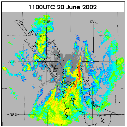
Rainfall totals from this system exceeded 200 mm in 24 hours at seven rain gauge sites, and much of that rain fell in only 1 hour. Radar imagery (Fig. 3) showed that the main band of rain was elongated in shape and moved southward down its length, delivering around 1 hour of intense rainfall to the western side of Coromandel.
Another smaller band of heavy rain passed over Putaruru, leading to flooding in that area.
A feature of this rainfall was the "sting in the tail" of the event, i.e., an intense band of rain was at the rear of the rain area, so that very heavy rain fell at the end of the rain event, after the catchments were already well saturated by earlier rainfall. This is a recipe for maximising the likely damage.
Significant flooding occurred in Waikawau, Waiomu, Tapu, Te Puru, Tararu, Te Aroha, Tirau and Putaruru (Figs. 1 and 4, above). Note that 'Waikawau' listed here, on the Coromandel west coast, is different to the place and bay on the Coromandel east coast also of the same name. Five major rivers and streams (Tararu, Te Puru, Tapu, Waiomu and Waikawau Rivers) and many smaller streams burst their banks. Return period analysis by Environment Waikato (based on both rain gauge and flow, Munro 2002) suggest that the storm was a 1-in-100 year event.
The Waikato Region utilises a variety of flood prevention and mitigation measures: these include stopbanks, floodwater pumping stations, floodgates, river and stream channel improvement works, soil conservation fencing, soil conservation planting and retirement, and soil conservation structures. Some of these were damaged during the Weather Bomb event (see Munro 2002).
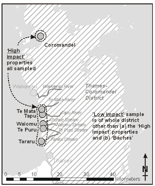
For the purposes of this study, we have defined several areas within the region affected by the weather bomb. The Coromandel 'high-impact' area is the section of the western Coromandel coastline from immediately north of Thames to Coromandel township (inclusive). In this 'high-impact' area, which includes Waiomu, Tapu, Te Puru and Tararu, as well as Te Mata and Coromandel, the townships occupy the valleys and coastal alluvial fans of several streams that had severe flooding. The 'low-impact' Coromandel takes in the remaining Thames Coromandel District. Flooding damage was also recorded by EQC and private insurers in the South Waikato District towns of Putaruru and Tirau in particular. The 'South Waikato' sample herein refers to a random sample from these two towns.
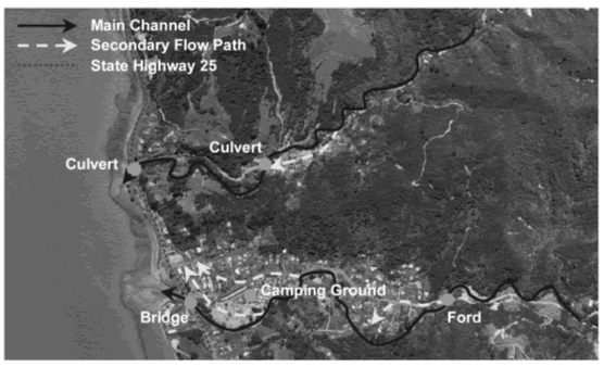
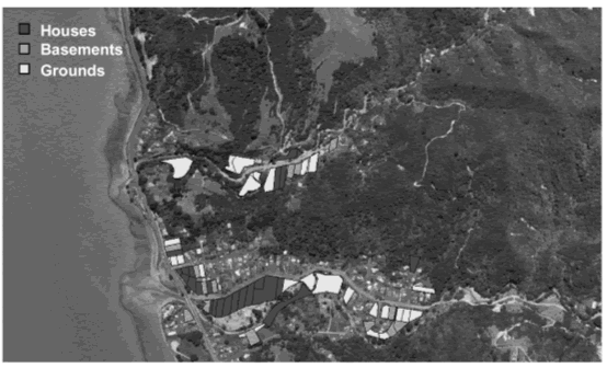
Large steep catchments caused flows to increase very rapidly. Inland of the west coast of the Coromandel peninsula, the flood waters remained largely confined in the valleys and gorges. Where these valley bottoms were populated there was extensive flood damage (e.g., Puhue Stream valley, on the northern fringe of Waiomu). As the rivers reach the coast, they emerge onto coastal alluvial fans. Here the flow rate of the flood waters exceeded the cross-sectional capacity of the existing channels, and flow spread out across the fans, following the easiest path to the Hauraki Gulf. The 'high impact' settlements listed above occupy extensive areas of these coastal fans, as they provide the only flat land along an otherwise steep, rocky coastline. Overtopping of stream channels across the coastal fans was exacerbated by the narrowing of channel width where the rivers flowed under the bridges for State Highway 25. These created a 'pinch point', forcing flood waters over the banks upstream of the bridge and increased the flooding depths across properties beside and down slope of the bridges (note the intensity of flooding on the properties north of the bridge in Figs. 5a and 5b). The flood waters contained abundant vegetation and debris and these tended to snag at the bridges, further compounding the problem. There was loss of life where one victim was swept away at the motor camp in Waiomu (Fig. 5b), on one of these coastal fans.
Two general surveys were used-these were designed to collect data from (a) households, and (b) businesses, within the affected areas, using identical research procedures across the entire sample. The questionnaires were developed to collect quantitative data specifically on the elements described below. Development of the questionnaires followed the method outlined by Dillman (1978), with particular attention paid to content and design focussed on enhancing the return rate.
The questionnaires are in Appendices 6 and 7.
- Households affected by the event were surveyed to determine:
- the losses (value) caused by the event (both direct and indirect) for households and communities alike
- disruption caused to infrastructure (e.g., power and roads) and the costs associated with this
- levels of preparedness, based on prior understanding of risks, and warnings given by the media and civil defence concerning this event
- changed perceptions of the risks among those affected by the weather bomb
- resultant changes in the level and nature of preparedness for future similar events by individuals, businesses and small groups.
- Businesses affected by the event were surveyed to determine:
- the losses caused by the event (both direct and indirect) for those businesses and whether they were insured
- any offsetting increases to business resulting from the event
- the history of flooding impacts to that business.
Both surveys also include full demographic questions compatible with national census data (see Section 1.5.3).
1.5.1 Method of Delivery
Staff from the Institute of Geological and Nuclear Sciences and Thames Coromandel Flood Project coordinators hand-delivered questionnaires to households that were directly affected by the flooding. The questionnaire was personally delivered to a member of the household, so staff members could explain the questionnaire and its purpose, as well as establish a rapport with the community. If no one was at home, a questionnaire was left at the property.
Other parts of the community, i.e., households that were indirectly affected, either received personally delivered questionnaires or were part a random postal survey. Questionnaires were also available on request, mailed out from council chambers.
A similar approach was taken to survey local businesses. Businesses that were directly affected were delivered questionnaires personally, and those that were indirectly affected were mailed questionnaires. Organizations and local authorities (insurance providers, EW, TCDC etc.) that were directly and indirectly affected were contacted for information they had regarding the event (See Appendices 4, 8 and 9 and refer to Munro, 2002).
Because of this method of delivery, a higher response rate and more comprehensive data set was obtained compared to that commonly obtained using a random postal survey. A postal-only survey would have been particularly hampered in the Coromandel area because of the large number of rural delivery and postal delivery centre addresses.
For the design of the questionnaire, staff from NIWA, GNS, MetService, MfE, NZIER, EW, and TCDC were consulted. This consultation process continued from late May through August 2003. The questionnaire was reviewed by staff of TCDC.
The surveys was hand-delivered and posted during September 2003.
Two weeks after the questionnaire was delivered, a reminder letter and replacement questionnaire were posted to those households that had not returned the questionnaire, again inviting them to participate.
1.5.2 Return Rates
Table 2 presents a breakdown of the survey return rates. The total domestic survey return rate was 33.1 % (439 responses) of those deliveries which did not fail. This contains a sample of 332 responses from households in the Thames-Coromandel District, out of a population of about 26,300 (ie. response from about 1.3 % of the district). The sample of 'high impact' houses with some financial loss was 137 (46 % of an approximate total of 300 flooded from Civil Defence estimates), of these 64 had losses over $10,000.
Failed deliveries occur when a mailed-out form is returned to the sender by the postal service because it cannot reach the intended address. The overall failure rate was 8.9 %. A failure rate of around 10 % is common for postal surveys and is primarily the result of inaccuracies in the address database. The database source here was provided directly by the district councils as a random sample from their rating databases.
Table 2: Survey return rates
|
Total sent |
Return to sender |
Fail % |
Total non-fail |
Returned blank |
Returned blank (% of non-fail) |
Returned complete |
Complete (% of non-fail) |
|
|---|---|---|---|---|---|---|---|---|
|
South Waikato: |
434 |
51 |
11.8% |
383 |
4 |
1.0% |
107 |
27.9% |
|
Coromandel low-impact: |
||||||||
|
(a) direct mail |
229 |
57 |
24.9% |
172 |
- |
0.0% |
47 |
27.3% |
|
(b) bach (owner mailed) |
269 |
14 |
5.2% |
255 |
4 |
1.6% |
72 |
28.2% |
|
Coromandel high-impact: |
522 |
7 |
1.3% |
515 |
4 |
0.8% |
206 |
40.0% |
|
DOMESTIC TOTAL |
1454 |
129 |
8.9% |
1325 |
12 |
0.9% |
439 |
33.1% |
|
BUSINESS TOTAL |
253 |
11 |
4.3% |
242 |
4 |
1.7% |
69 |
28.5% |
There was a relatively high failure rate for the Coromandel low-impact area. This is likely a result of returns from rural sections, which have no means of postal delivery but are directly rated (i.e., rates are paid from that address). This failure rate was already dramatically reduced by a careful effort to remove addresses that are not serviced by rural delivery, and separating out addresses that were clearly owned outside of the district and were thus probably holiday homes or 'baches'. For this latter group the forms were directly mailed to the owner (outside of the district). The failure rate for this group was relatively low (5.2 %), as these addresses were almost exclusively in suburban areas with full mail delivery services.
The Coromandel high-impact area was considered the most crucial dataset, for which it was especially important to maximise the return rate (a rate of 40.0 % was achieved). The high return rate and extremely low failure rate here (1.3 %) is the result of these questionnaires being hand-delivered to the household's door.
The number of surveys mailed out took into account forecasted failure and return rates and the total sample of completed domestic questionnaires was 439.
The return rates cited in various studies using identical freepost-return questionnaires vary considerably. Overseas studies have reported return rates as low as around 20 % (e.g. Davies, 1989) and as high as 80 + % (e.g. Perry, 1990). Recent New Zealand studies published by the authors consistently get rates from around 20 % (e.g. Miller et al., 1999) to just over 50 % (e.g. Johnston et al., 2003).
The business survey was a subordinate dataset and conducted on a much smaller scale than the domestic survey. The return rate was 28.5 % (a sample of 69 businesses) with a failure rate of 4.3 %. This failure rate was low because some of the questionnaires were hand delivered and most businesses were located within settlements with regular mail delivery.
With a sample of 439 the margin of error for the domestic sample is 4.8 %, and 12.0 % for the business sample of 69; we can be confident that 95 % of the time the real statistic for the whole population is within the margin of error of the statistic obtained from the survey sample, as long as the sample is representative (see below).
1.5.3 Assessment of representativeness
As a measure of sample bias, demographic characteristics collected from the questionnaire are compared to the 2001 census in Appendix Table A2.1. Census results starting from the age bracket '15 and over' were used as this was the most suitable cut-off available to correlate to the age 18 and over respondents to the survey. A sample bias is common in almost all surveys, however there is usually sufficient variation to ensure that sample bias does not negatively affect the general conclusions drawn from these types of studies. The sampling method also reduced bias as much as possible. The relatively high return rates achieved also reduces sample bias.
The gender balance is within the margin of error for all areas. Age is skewed towards older respondents in all areas (especially those over 60, with a contrast of a particularly low under-30-years-old response). This is a common situation for voluntary response questionnaires. In terms of household composition, people living alone are slightly underrepresented whereas families without children are slightly overrepresented (this is strongest in the Coromandel 'low impact' area).
Europeans are overrepresented compared to all other ethnic groups, however this is not extreme - less than 2.0 % beyond the margin of error, for all areas other than South Waikato. The South Waikato sub-sample has twice the margin of error too large a proportion of Europeans, and a similar margin too few Maori, compared to the 2001 census.
There is a significant skew in educational qualifications, with a substantial (nearly four times the margin of error) lack of respondents with no school qualifications. In contrast, those with University Degrees contribute about twice the margin of error more respondents than their proportion in the census data.
The skew in most income brackets is slight towards a greater representation of the higher income brackets (most are within the margin of error, but the proportion or respondents with household income > $50,000 gross p.a. is about one and a half times the margin of error higher than for the 2001 census). There is a skew towards those not in paid employment, compared to those in full-time employment, for the whole sample.
Table A2.2 presents the length that the household has lived in that community and home. The mean length of residence in the community for the whole sample is 19.8 years, with the lowest being the Coromandel 'high impact' sub-sample (mean 17.6 years) and highest 'South Waikato' (mean 25.0 years). The mean length of residence in this home for the whole sample is 13.2 years, with the lowest being the Coromandel 'low impact' sub-sample (mean 10.5 years) and highest Coromandel 'bach' (mean 15.2 years).
1.5.4 Analysis
Data from the questionnaires has been coded and stored for analysis using the Statistical Package for the Social Sciences (SPSS/PC+) program.
All answers used in the residential economic impact assessment (Appendix 3) are for the household as a whole, whereas all social data presented in Appendix 5 are for the respondent only. Business survey responses are for the business as a whole (Appendix 4).
See more on...
1. Introduction
March 2004
© Ministry for the Environment